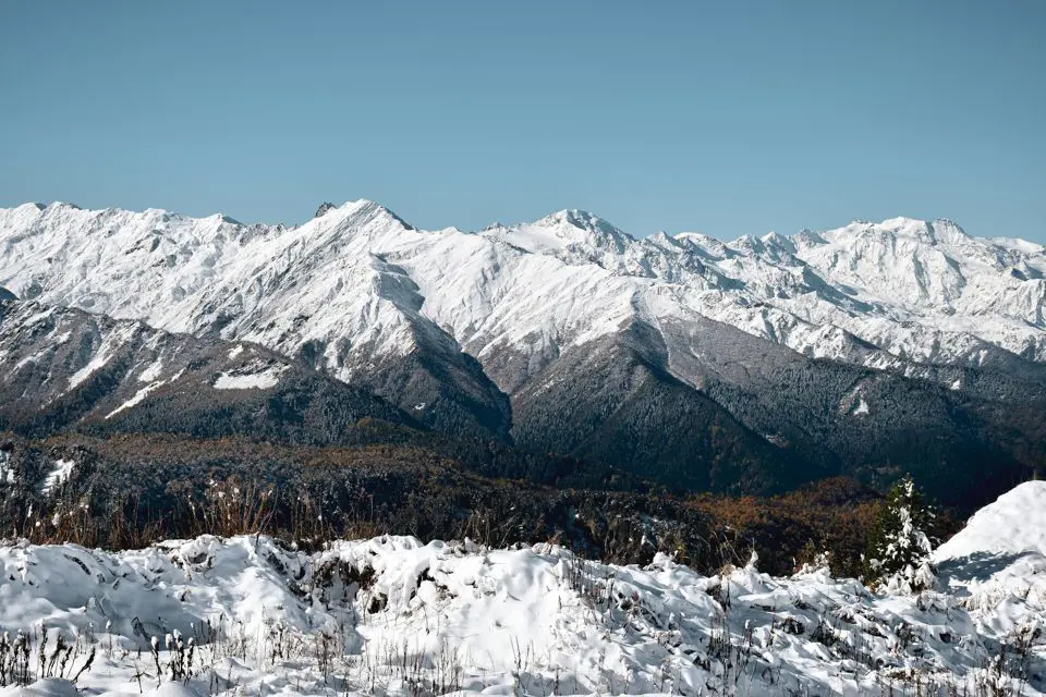
A Patagonian mountain where the calving of its glaciers causes impressive roars, similar to the thunder of a storm. That is Cerro Tronador, one of the most imposing places in Nahuel Huapi National Park, the natural treasure surrounding the famous city of San Carlos de Bariloche, in the province of Río Negro.
Located south of the Andes mountain range, right on the border between Argentina and Chile, this inactive volcano separates two national parks: Nahuel Huapi, on the Argentine side, and Vicente Pérez Rosales, in Chilean territory. Its summit of 3,554 meters above sea level dominates the horizon. Every year it summons thousands of travelers arriving in southern Patagonia to see its glaciers, forests, rivers, and waterfalls.
A few kilometers from downtown Bariloche, the road to Tronador is an experience in itself. Traveling from the city to its base means traversing some of the most spectacular landscapes of Nahuel Huapi National Park, among lakes, rivers, mountains, and panoramic viewpoints.
If this plan excites you, in this article we are going to tell you how to go to Cerro Tronador from Bariloche, what you will find on the tour, and what is the most practical and advantageous way to visit it.
tours to Cerro Tronador
As we noted at the beginning, with your own vehicle, it is possible to arrive and tour Cerro Tronador without inconvenience and with total comfort within the established schedules. However, with a private excursion, the experience is notably improved: the accompaniment of professional guides, added to transfers and knowledge of the gravel roads that must be traveled, turn the ride into a much more comfortable and practical experience.
Meanwhile, one of the most chosen ways to get to Tronador is by hiring an excursion with Best Bariloche Tours, a leading nature tourism agency in the region. The company offers two main options combining unique landscapes, transport included, and the assistance of specialized guides in Nahuel Huapi National Park.
The first alternative is the Cerro Tronador Excursion: Mountains and Glaciers for the Day, a complete experience touring the lakes, rivers, and viewpoints of the journey until reaching the Ventisquero Negro. It is ideal for those seeking to know the mountain without worrying about circulation schedules or the state of the roads. The guides explain the volcano's geological history, the formation of glaciers, and the park's ecosystems, turning the tour into an educational and sensory experience.
The second option is Hiking in Cerro Tronador with Transfer, designed for travelers wishing to experience the mountain more actively. This tour combines transport from Bariloche with a guided hike along trails crossing forests and natural viewpoints, with views of the Manso River and the mountain's glaciers. It is a perfect activity for those enjoying direct contact with nature and those seeking to take spectacular photos of the Patagonian environment.
Both excursions depart from downtown Bariloche, include round-trip transfers, professional accompaniment, and stops at major panoramic points. In addition, they allow making the most of the full day without worrying about logistics or the park's transit schedules.
Where is Cerro Tronador?
As we indicated above, Cerro Tronador is located in the southern area of Nahuel Huapi National Park, within the province of Río Negro, approximately 90 kilometers from Bariloche. The distance from Bariloche to Cerro Tronador is covered in about two and a half hours, although the time may vary depending on road conditions and stops made during the journey.
The route is largely done via National Route 40, one of the best known in the country for traversing much of its length. From that road, you skirt lakes Gutiérrez and Mascardi until reaching the southern entrance of the park. Then the road continues along Provincial Route 82, a gravel stretch crossing forests, natural viewpoints, and crystal-clear rivers until reaching Pampa Linda, the small hamlet where the ascent to the mountain begins and where the base of the famous Ventisquero Negro (Black Glacier) is located, one of the most visited glaciers in the park. We'll get to that part.
Why is it Called "Cerro Tronador"?
According to locals, the mountain was named "Tronador" (Thunderer) due to the noise similar to thunder produced by ice calvings in the glaciers. Although it sounds attractive from a sensory point of view, in practice, hearing that strident creak is not good news.
It turns out that this mountain range has seven main glaciers, but unfortunately, all are in the process of retraction due to climate change. Many lucky tourists have the opportunity to witness from the viewpoints the moment when a block of ice detaches and falls onto the dark slopes of volcanic rock, generating a deep and resonant sound that propagates through the valleys.
Meanwhile, in addition to its spectacular geology, Tronador is a site of high natural value: its surroundings are covered by native forests of coihues, lengas, and ñires, crossed by rivers such as the Manso Superior, whose waters change color along the route. It is also habitat for birds such as the kingfisher, the giant woodpecker, and the Patagonian huet-huet, species typical of the southern mountain range.
road to Cerro Tronador from Bariloche
The most common way to visit Tronador is starting from San Carlos de Bariloche with private transport (cars, trucks, motorcycles, and bicycles are allowed) or through an organized excursion. The complete journey to the base extends about 225 kilometers round trip.
Prepare the mate kit and good music to accompany a two-hour journey from downtown Bariloche to the entrance of Nahuel Huapi National Park. First, take National Route 40 South towards El Bolsón. During the first kilometers, the road winds between lakes Gutiérrez and Mascardi, offering very beautiful panoramic views of mountains such as Cerro Bonete and Cresta de Gallo. As you advance, beaches of dark sand and viewpoints appear where it is worth stopping to contemplate the landscape or take photographs.
Passing Villa Mascardi, turn right onto Provincial Route 82, which crosses an area of virgin forests and meltwater streams. In this section, you can visit ideal places for fly fishing, such as Lago Los Moscos, Río Manso, and Lago Hess. After crossing the Los Rápidos bridge—where trout can often be seen swimming under the crystal-clear water—the ascent towards Pampa Linda begins, the point where nature, tourism, and the mountain converge.
In Pampa Linda, there are tourist services such as cafes, restaurants, bathrooms, and even accommodation. Views of the Tronador glaciers are magnificent, but it is just the beginning. From there starts the last stretch to the Ventisquero Negro, the mountain's most accessible glacier, famous for its dark color, a product of the mixture between ice and volcanic sediments. The contrast between the white of the upper glaciers and the black tone of the ventisquero creates a unique postcard of Andean Patagonia.
Timetables and Recommendations of Nahuel Huapi National Park
The entrance fee to Nahuel Huapi National Park is accessible for all types of visitors and can be checked on the official National Parks website, along with ecological rules for visiting or staying overnight within the reserve.
To ensure visitor safety and preserve the natural environment, access to the road connecting Los Rápidos with Pampa Linda is subject to specific circulation schedules. It is important to respect them, as the route is mountainous and has one-way sectors.
Direction Los Rápidos → Pampa Linda: from 10:30 AM to 2:00 PM
Direction Pampa Linda → Los Rápidos: from 4:00 PM to 6:00 PM
Two-way traffic: from 7:30 PM to 9:00 AM
Before starting the trip, it is recommended to check the state of the roads and weather conditions at the Nahuel Huapi National Park offices or at the tourist information centers in Bariloche. During winter, snowfall can cause temporary closures or traffic restrictions.
Best Time to Visit Cerro Tronador
Cerro Tronador can be visited throughout the year, but each season offers a different experience.
In summer, from December to March, the climate is milder, and roads are fully enabled. For many, it is the ideal time to enjoy trekking and to watch and photograph the fauna and flora (the latter is at its greatest splendor).
During autumn, from April to June, the forests of Nahuel Huapi turn into a landscape of gold, red, and orange. That is, a very picturesque and beautiful scenery to walk and portray Patagonia.
In winter, from June to August, the peaks are covered with snow, and the atmosphere becomes more silent and magical, although it is necessary to be well informed about the state of the road and entry restrictions.
And in spring, from September to December, the thaw gives rise to waterfalls and rushing rivers, and the vegetation recovers its intense color.
Tips for Visiting Cerro Tronador
Although the route is well-signposted and suitable for all types of visitors, it is worth keeping in mind some basic recommendations. If going on your own, it is essential to leave early from Bariloche, have a full tank or sufficient fuel, and respect access and return times. The gravel road may have potholes or slippery areas, so driving with caution is suggested.
It is also important to bring warm clothing, even in summer, as the temperature drops considerably in higher areas. On the other hand, it is recommended to wear comfortable shoes, sunscreen, bring water, and light food.
Being a protected area, lighting fires or leaving waste is not allowed. At main points, there are enabled rest areas and cafes where regional products can be tasted.
Published by Has Chacon on 08/06/2026